
About IMIS
IMIS is an open-source GIS-based Digital Public Infrastructure (DPI) which functions as both a municipal information system and a software solution, integrating data, processes, and services to enhance municipal governance—particularly in sanitation management with Citywide Inclusive Sanitation (CWIS) approach to achieve SDG 6.2. It offers municipalities data-driven decision-making tools to strengthen governance across various sectors. By leveraging open-source technologies and Geographic Information Systems (GIS), it facilitates:
- Planning, management, and monitoring of sanitation systems using the CWIS approach.
- End-to-end FSM (Faecal Sludge Management) service chain oversight, including real-time data tracking.
- Generation and visualization of CWIS indicators for performance assessment.
- Intuitive dashboards for tracking CWIS indicators, Key Performance Indicators (KPIs), and other essential municipal governance metrics.
Citywide Inclusive Sanitation (CWIS)
CWIS is an approach to achieve SDG 6.2 for safe, equitable and financially viable sanitation systems and services. CWIS ensures everyone in a city has access to safely managed sanitation, and human waste is safely managed along the whole sanitation service chain ensuring protection of the environment and human health.
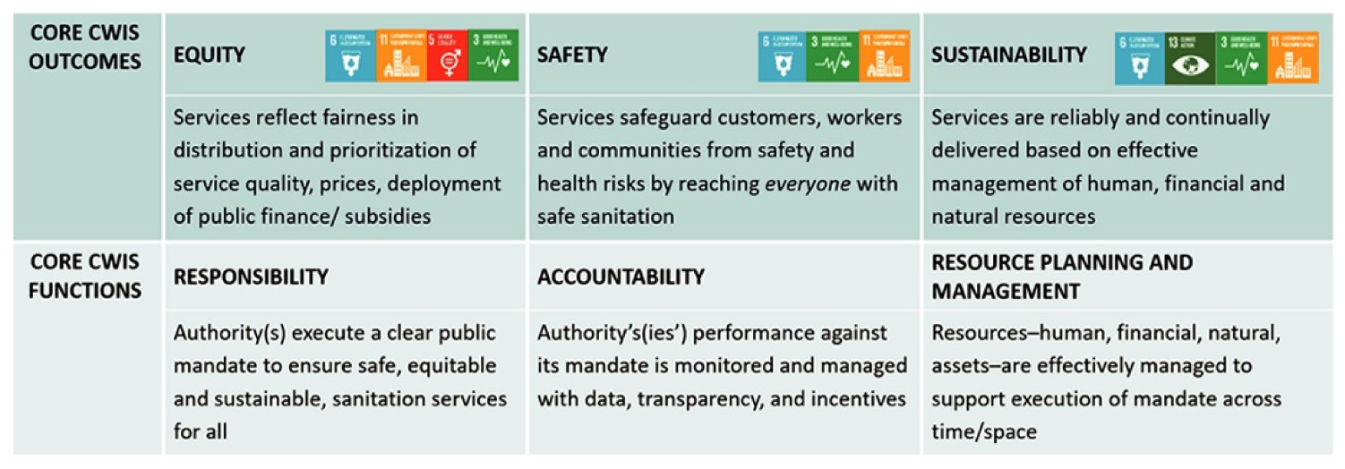
CWIS approach focuses on service provision and its enabling environment rather than on building infrastructure, therefore, reliable data is the key success factor for CWIS. UN Water SDG 6 global acceleration framework has also identified data and information as one of the five accelerators of SDG 6 outcomes.
Features of IMIS
- Spatial context for municipal data - infrastructure, services, and resources
- Efficient storage and management of municipal data, including infrastructure and essential services
- Integration of CWIS data to support planning, management, and evaluation of sanitation systems and services
- Decision support tools for decision-making based on spatial analysis and modelling
- Real-time dashboard for monitoring KPIs and CWIS indicators
- User-friendly interfaces with access control features
- Scalability to adapt to the evolving technology and information needs
- Mainstreaming CWIS service chain into the city's business process
- Interoperable with external data sources, including tax/revenue, public health, emergency response data and more
- Robust security measures to safeguard sensitive data, ensuring city data privacy compliance
Functional Modules

Building Information Management System
- Maintains information about all existing and new buildings with their building footprints, sanitation system, socio-economic condition, etc
- Maintains information about low-income communities with their geographic coverage and sanitation system

Property Tax Collection Support System
- Enables to import of property tax or other revenue data into IMIS for spatial visualization of buildings or containments with their tax or revenue collection status

Urban Management Decision Support System
- Dashboard for monitoring the situation of sanitation and other elements required for planning, management and monitoring and evaluation of CWIS
- Dashboards for monitoring KPIs and CWIS indicators
- Tools for real-time monitoring of the sanitation service chain
- Spatial analysis tools
- Query and attribute analysis tools
- Basic navigation tools for exploration, analysis, and visualization of spatial data within a GIS environment and tools for printing maps

Utility Information Management System
- Maintains road network information
- Maintains water supply network information
- Maintains sewerage network information
- Maintains drainage network information

Solid Waste Information Support System
- Enables import of solid waste management data into the system for spatial visualization of buildings with their solid waste management status

Water Supply Information Support System
- Enables to import of water supply bill payment data into the system for spatial visualization of buildings with their bill payment status

Public Health Information Support System
- Maintains information about hotspot areas where waterborne diseases occurred

Public/Community Toilet (PT/CT) Information Management System
- Maintains information about all PTs and CTs in the city with the number of users used and their feedback

Sewer Connection Information Management System
- Maintains information about all buildings and their corresponding sewer network

Fecal Sludge Information Management System
- Maintains information about all containments with their geographic location
- Maintains information about FSM service providers and their resources
- Maintains information about the Fecal Sludge Treatment Plant and the FS disposed records
- Maintains the quality test record of treated wastewater and compost generated from the treatment plant
- Maintains records of services from containment emptying to transport, and desludging of FS in the treatment plant
- Maintains the customer feedback data